Built in the 1930’s by Stalin’s Gulags, it is a testimony to the hardships endured in the minus 40+ degrees winter and in summer, the swamps and mosquitoes. Today, although not a tough 4x4 track, one has to be well prepared, and self sufficient in vehicle recovery. Although technically possible in winter, the most convenient time is after the spring rains have eased and the rivers subsided in late June early July.
In 2007, our plan was to ship our 40ft container to Magadan; however that proved impossible as Russian customs decided that the container must be customs cleared at the first port of call into Russia. i.e. Port Vostochny about 120Kms north of Vladivostok. That caused us three weeks of delays, but we did achieve being the first ever foreign vehicles to be every cleared from that port. My suggestion would be to ship a container to Vladivostok (where clearance is ‘relatively’ easy in about 3 days) then to on-ship in a container to Magadan.
The Temporary Import Documents would need to be obtained in Vladivostok and then send the vehicle to Magadan via the Fesco Shipping. Fesco sail every week Vladivostok/Magadan.
This is the service timetable from Vladivostok and Vostochny: http://www.tma.ru/showservice.php?serviceid=fml&locale=en
The only down side of this, is the sailing that takes 10 days, and this time has to be allocated into your itinerary.
As the above was impractical for us at the time we chose to drive from Vladivostok to Yakutsk to Magadan then return to Yakutsk on the same ROB route, then south to Mongolia. Today a new road is open north of the Road of Bones and links from the turn off (N62' 55.534 E137’ 15.300) to the old Gulag camp of KYUBUME to the the turn off (N63’04.357 E147’00.378 ) to the ARKAGALA River near the deserted town of KARDYKCHAN. Hence it is now possible to return via a different more northerly route.
The ROBs trip would take about 10 days to complete. From Yakutsk the following were our run times.
-
✦ Day1: 72Kms in 5 Hrs, Road Speed 45-50Kph, Ave Speed 14Kph incl barge ride
-
✦ Day2: 290Kms in 11 Hrs, Road Speed 45-60Kph, Ave Speed 27Kph
-
✦ Day3:232Kms in 13 Hrs, Road Speed 45-60Kph, Ave Speed 19Kph
-
✦ Day4:167Kms in 8 Hrs, Road Speed 30-50Kph, Ave Speed 23Kph
-
✦ Day5:206Kms in 10 Hrs, Road Speed 25-50Kph, Ave Speed 22Kph
-
✦ Day6:106Kms in 14 Hrs, Road Speed 10-40Kph, Ave Speed 8Kph
-
✦ Day7:173Kms in 11 Hrs, Road Speed 10-35Kph, Ave Speed 16Kph
-
✦ Day8&9:625Kms in 6+9 Hrs, Road Speed 50-70Kph, Ave Speed 18Kph.
For repairs in Yakutsk contact Raoul on 712-512 or polarcar@sakha.ru
In Magadan contact Sergey on 8-914-851-41-43 both these guys are members of the local 4x4 clubs and can direct or help.
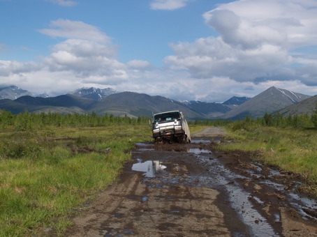
The trip sheet below lists the distances and GPS points of interest, barge crossings, turn offs etc. The road from Yakutsk to the Kyubyume/Tomtor turn off, and from the turn off north of Susiman to Magadan is good gravel. In between the track is a continuous line of puddles and bog holes. Here track repair is inevitable, particularly in relation to erosion in the gullies and slippage on the side of hills.

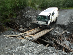
Be cautious of the bridges, many have make shift repairs, and some should be avoided altogether. There is no maintenance on the track apart from passing travellers, and our concern is that the major bridges will not last for too many more seasons.
DOWNLOAD Road of Bones trip sheet:
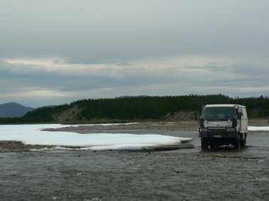
The Soontar River at Kyubyume is wide and splits into four rivers at the GPS point listed. The crossing point follows the top of each set of rapids and then winds its way through the swamp land on the eastern side.
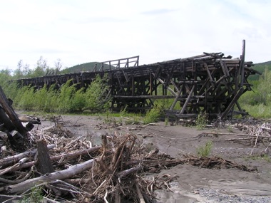
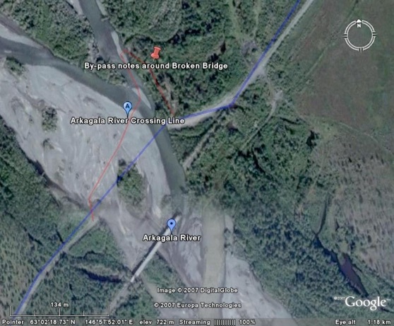
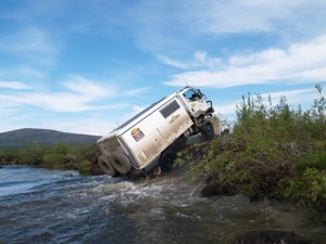
The Arkagala River is also fast flowing. Cross on the northern side of the old bridge by first following the track through the timber line on the Magadan side, then cross to the south of the island and then select the shallowest part.
There are very few travellers on this section of the road and you must be prepared for self recovery. The long mud holes on the track can also be captivating. A winch is mandatory within the group as is a snatch strap, shovel, and pick.
The mosquitoes are in plague proportions. RID (50% deet) is a must as is long sleaves, trousers, and netting over your head. Our best defence was a $99 mosquito net mess tent where we could cook and eat comfortably.
Fuel and magazines (shops) are at Yakutsk (439Kms to) Khandyga (479Kms to) Kudasun/Tomtor (352Kms to) Susuman (431Kms to) Atka and (200kms to) Magadan. There are other fuel stops available, but not between Khandyga and Susuman.
The Lena River Barge operated regularly and the one hour trip costs about 560RUB (A$22). The loading position north of Yakutsk is easy to find, but be prepared to just keep pushing your way up the que, as the eight or so ‘lines’ of vehicles converge into one. On the east side the loading/unloading position seems to change hence I have listed the two positions that we used. On the Aldan River the barge operates very irregularly about twice a day, and the two hour trip cost 2,000RUB (A$80) for our size trucks. The small Combi sized Uaz’s pay around 1,000RUB. At Keskil on the east side the river height is variable and the loading positions change accordingly.
Many maps show a road looping north from Kyubyume to Ust’-Nera, Ozernaya and Susuman. As at June 2007 the road east of Ust’-Nera was unfinished by 14 kilometres plus a major bridge project was yet to be undertaken. Once completed this road will become the access from Yakutsk to Magadan, and the original ‘Road of Bones’ will unfortunately slowly return to the swamps.
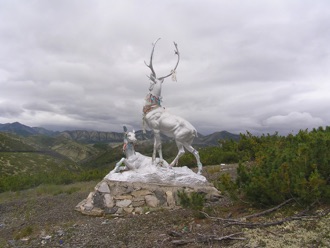
An interesting side trip is up to an old Gulag Camp and the Elchan Mountain Pass some 190kms off the road about 100Kms east of Khandyga.

A visit to the modern ghost town of Kardikchun north of Susuman is also a must.
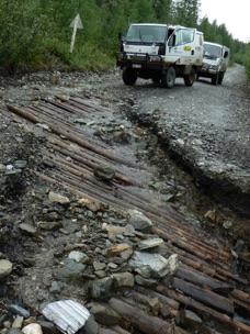
When travelling the Road of Bones look for the original road building techniques that the prisoners used to construct the road across the swamps. When in Magadan go to the museum to appreciate the hardships that millions endured.
To read the road signs etc some knowledge of the Russian Cyrillic alphabet is essential, and not difficult to learn.
You can view the track line and notes on Google Earth at:
The Road of Bones is an adventure, the scenery spectacular, and the people very friendly. If you are thinking of going, my suggestion is first get out a big black felt pen and mark the time slot through the calendar. Everything else must then fit around that time frame.
Herewith a brief of our travels in June/July 2007:
Having just loaded two trucks into a 40 foot container we feel totally exhausted. Not because of the manual work, but because after 9 months of planning, the realisation has hit us that an adventure was about to happen. Perhaps also, the relief that the vehicles actually fitted into the container contributed to our feelings.
Inspired by the book ‘A Long Way Round’ the adventure would be a drive of some 20,000 kilometres across Russia and Mongolia and would include the Kolyma Highway, better known as the notorious ‘Road of Bones’
The internet proved a valuable source of information and my internet time was logged at over 250 hours. Critical in all the research was the time slot for travel. The 2,200 kilometre track from Magadan to Yakutsk would only be open for about three weeks towards the end of June. Winter travel, although technically possible in the minus 30 to 40 degrees weather following December was not our style of holiday, and as the weather warms towards spring, the melt water is added to by the May rains turning the rivers wild and the tracks into impassable tundra slop. This leaves the few weeks around June/July as the only time for travel
In the 1930’s, Stalin sent prisoners to build the road from Magadan to Yakutsk, these Gulag prisoners toiled for 14-hour a day even in winter, leaving few survivors and many frozen bodies along the way, hence the road become known as “The Road of Bones”. This track is now rarely travelled, is not maintained, and there are no trip notes available. We had a challenge before we started even to find out if it was passable, and would never know, until we actually drove it.
Our first hurdle was the Russian bureaucracy. Our container was offloaded in Port of Vostochny (140Kms North of Vladivostok) and customs insisted it be cleared there before shipment to Magadan. In summary we were the first vehicles ever to be cleared in Vostochny and it cost us 21 frustrating days. In the end, with the help of some wonderful local companies, we had our trucks and decided to drive from here to Yakutsk/Magadan/Yakutsk, then on to Mongolia and Europe. It is only an extra 10,000 kilometres over some of the worst roads in the world and the only thing that is worse than the roads is the Russian System and we had endured that.
To keep to our schedule we had to be in Yakutsk some 3,300 kilometres away, in five days. The distances are vast and the roads very slow going. Our biggest day was 761Kms in 18 hours, and most of that at 35km per hour. This far north, the roads are built on permafrost. Being ice, it is constantly moving and with the passage of the heavy trucks, the road surface is destroyed. In places the road has up to 1 meter high ‘hills’ and then valleys of slop where the trucks have broken through the surface to the swamp below. Our vehicles rock and roll; and occasionally break through the soft under layer to the bottomless peat bog below.
Just on the northern side Yakutsk is the very first challenge, getting onto the Lena River barge. There is no system and lining up was just too simple. Semi trailers, logging trucks, trucks with farm machinery, private vehicles of all description and lots of small comb like Uaz vans all jostled for loading. At first we were too just polite and missed the earlier barge, now we must do as the locals do. One local car cost him his indicator light fighting with my bull bar, and that did not faze him as he still pushed forward grinding his right hand guard along the bull bar to finally secure one place in front of me.
The trip to date took us through vast native pine country dotted with swamps and small lakes. It is summer now and the Yukultian villages are enjoying the warmth. We have been told that next week all the villages will be empty as all the workers will be in the field harvesting the local grasses for winter feed. Most of the locals wave as we drive by slowly. Their faces are weathered, again a reflection of the hostile environment, but their spirits are high. They are cattle and horse breeders, using both as meat and milk providers, and as a means of transport. Great importance is placed on community teamwork and high respect is held for those who have passed before them. The forbearer’s graves are ornate and hold prime position on the sides of hills overlooking the lakes, valleys and villages.
At 375 kilometres from Yakutsk we arrive at the Aldan River. We decide it is too late for evening barge crossing and camped with the thousands of mozzies on the river bank and watch the cargo ships move up and down. The rivers in Russia are big, very big; the Lena was more than a kilometre wide and the Aldan at least half that.
At 2000RUB(A$80) for the 2 hour, 9 Km barge trip we at first thought was expensive, but the small grey ‘Uaz’ vans were charged 1000RUB. There were 6 of them and our two trucks on the barge which seemed to operate very irregularly about every 2 hours from 6 am till 9 pm.
We think we are on an adventure, to the locals it is just a road. One young man pointed to the water and indicated a height of 2 meters as being the ‘normal’ forwarding depth for the rivers ahead. We measure that on our trucks and think….. “Interesting”
We unloaded directly onto the river bank at the small village of Kiskil and then drove the 26km along a moraine gibber road west to Khandyga. Khandyga is an old town, everything is broken, and there is junk and broken machinery everywhere. The dusty roads wind past grey timbered single story buildings, and the occasional multi story old concrete block that is slowly decomposing with concrete rot. Everywhere there are huge piles of coal just dumped at random for the winter season. One can only think that in winter at least the snow must cover all the untidiness.
Following refuelling and topping up our supplies at the local ‘magazine’ we headed out of town, refuelled for the 800km run to Susiman, the next slightly major town on the other side of track that we still have conflicting reports on weather it is actually passable
Stopping later on a concrete bridge for a ‘comfort’ stop and were soon joined by a Kamaz truck that had come from the direction we were heading. Interestingly they told us that only yesterday the river at Kyubyume was 2 meters deep and showed us the line on the Kamaz’s cab door of the water height. We have also heard of an ice bridge and maybe a forwarding that the small Uaz vans use to the south of the broken bridge. We will have to make that decision when we get there.
We drive along spectacular one way tracks cut into the side of the near vertical cliff. 150 meters below was the fast flowing river, along its edges, and as a surprise to us were great sheets of blue ice, remnants of the last winter.
This track was hand cut into the rock by the prisoners of the Stalin era. Here six months was a lifetime, if you were not dead you would wish you were. Being here one still can not comprehend the hardship of the -30 and more winters, the swamps, the rain, the ice, and the plagues of mosquitoes and sand flies. Most of the villages in the area both occupied and deserted are the remains of the gulag camps.
We climb over a mountain pass at 1300meters and continue to drive along the remnants of wide glacial valleys. The density of pine trees is less now and we are in more Tundra country. In the distance are sharp pointed mountains with a dusting of icing sugar.
We reach the turn off to Kyubyume and Tomtor. Here the track splits, north will eventually be the new road to Magadan, as yet unfinished by 14 kilometres and a major bridge crossing yet to be constructed. East is to Magadan on the original ‘Road of Bones’.
Just after the turn off is the old broken bridge and beside it on the left is a track into the fast flowing and deep water. This was the track the Kamaz trucks have been using. Back up the Yakutsk road about 500 meters is a small down hill rough track used by the local small vehicles. The water was still fast but only about thigh deep. The water is freezing cold, focking painfully cold actually, because only 200 meters to the right was a huge ice shelf covering an area of at least three plus square kilometres. With hubs locked in, we crossed following the chosen line along the head of the four sets of rapids. The crossing was fortunately uneventful, but interesting driving across the rapids, around and through the marshy swamp areas, and between the large lumps of blue ice.
Kyubyume, on the other side was completely deserted. The houses were showing the decay of the harsh winters, and the roofs falling in from the weight of snow. Inside some places looked as if the occupants had just walked out. A beanie on the back of the chair, a pair of socks on the bed, and an old cross cut saw next to the wood pile. We found the movie theatre with racks of chairs and the old projector and film on the floor. The town was picturesque but at the same time eerie.
Our camp site some 28 kilometres further was surrounded by a lake on three sides with a back drop of pine trees and multi coloured ground lichen. As we fell asleep with the falling rain, we wondered how it would affect the river levels ahead.
We travelled over old bridges where they existed and around them where they had been washed away. The road is more difficult today with the light rain of last night. The scenery continues to be stunning as the wide valleys stretch up to the mountains that surround us.
We reached Tomtor at around midday. This little town boasts the lowest temperature recorded on earth at minus 71.2C. Last year they recorded minus 69.5C.
Following refuelling at the antiquated fuel pumps at Cudaysung, 5Kms west of Tomtor we head out of town. About 25 km out we cross an only just standing log bridge, it has been constantly repaired but nature and the pull of the fast and mighty river is slowly winning. I think it will be lucky to last another year; my fear is that once this and the other such bridges are gone so has access to this historic road.
After crossing the bridge the road becomes a track. There is now grass growing down the centre line and shows all but no maintenance, other than for rocks or logs dropped into washouts by other travellers. It has deteriorated to a long 100km line of bog holes, puddles and stony flooded creek crossings. The track winds up and down river valleys between the mountains and over mountain passes. We passed by more frozen rivers and large sheets of ice in the shadowed valleys.
It was only time before I got stuck in a long bottomless mud hole. Typically after 4000kms of travel we were just not prepared for getting stuck, and it took a little time to find winch extensions, tree protectors etc. Our winching points to the large pine trees then proved inadequate. As we winched the tree and all its root system just moved through the peat bog towards the vehicle. Strapping two trees together and one of us also holding the tree proved to be the answer. Once in order however, the TJM Ox hydraulic winch slowly pulled us from the thick mud.
There were many more river crossings and endless lines of mud holes. Many had firm gravel bottoms but not all. It was a task recognising the difference. According to the GPS we had 400 metres to the next river. When we arrived, the river was only a trickle below the old washed out timber bridge. That seamed unusual…..500 metres on was the answer.
Following the last heavy rains the river had changed its course and had cut a new path to the east of the old river and through the road. We now had to cross a shaley loose bottomed river and the exit point was a near vertical metre cliff up to the road. To the left and right side of the road was thick swamp. There was no choice but to do some serious road works to improve to ramp angle out of the fast flowing creek.
The water in the creek was cold from the melting ice. I mean seriously cold. One crossing carrying the shovel, etc and you stand on the other side and your feet are in so much pain, you can only stand there and blaspheme until the pain subsides.
Slowly cutting away at the compacted stony road base was hard work. It took an hour before we were prepared for our first attempt. Both the Isuzu and the Canter have limited slip differentials in the rear, and the bank was scaled successfully by both trucks.
It was not long after this we called travelling quits for the day and found a beautiful spot below a bridge in the stony creek bed. Joining us were the billions of hungry mosquitoes. The pyrethrin treatment we did of some of our clothes achieved nothing. Our best defence was the spray on RID (50% det) plus long sleeves, trousers and netting over our heads. Our $99 mossy mess tent was the best protection.
The worst part of the day was that personal moment each morning when you had to wander off into the bush. The mosquitoes would then attack every vulnerable part of the body presented to them.
The track continued with numerous mud holes, slippages on hill sides, and wash outs where the water had undermined the road. Slowly this track is disappearing, the bridges are falling apart, and on the side of hills, erosion is washing the track into the valleys below. . How much longer will it last – may be a season or two at best.
Our last final big river crossing is to be the Arkadela River. We had seen this river crossing viewing down from Goggle Earth, with its long washed out bridge. To not successfully cross this river would mean a return to the start of the track some 800Kms back.
With the arrival at the river, the first thing we notice is the bridge has been further washed away from photos we had seen on Google. No longer was it a line of pylons supporting some of the bridge. Only the western part remained, the most recent flood had cleared the eastern side of the bridge completely and that was lying some 200 metres down stream.
The floods of the last few days had also left fresh wet mud in abundance, and the water was still running a silty colour. A walk across the fast flowing section confirmed it was knee deep for 100 meters, then thigh deep for 30 meters before reaching the stony island; it was then only a still water pond before the muddy track through the timber line back to the original road on the other side.
Both vehicles crossed the river without incident, and we had thus successfully completed the Road of Bones.
20Kms up the road is a ‘T’ junction: Right and East to Magadan and to the left the new as yet uncompleted road North and West back to Yakutsk.
Before continuing, we had been told of a deserted town we must visit. Kardykchan had a population of 20,000 people when in the hight of winter in 1992 the towns heating plant broke down and could not be repaired. All the inhabitants were evacuated. This was the time of perestroika and the coal mining company did not have the funds to repair the heater hence the town just ceased to exist.
It was very uneasy driving past vast the sets of 6 story apartment buildings, the gymnasium, and the schools. The town cultural centre with the now not so proud statue of Lenin’s head was at the centre of the town square. To the right was the empty cinema still with the last billboard for the movie showing and the scattered chairs, and on the left, a deserted educational facility.
Surrounding the concrete jungle that made up of the main part of town was the deserted shantytown with their dark grey scrap timber houses, vehicle boxes, and all important glass houses. Everywhere there was junk, overturned vehicles, broken machinery, furniture, etc. Obviously the town had been robbed of anything of value, and was continuing to be so. As we were leaving we saw a truck load of scrap steel on the back of a very old 6x6 truck and trailer. This was bound for China who is hungry for scrap steel.
I wondered at the value of transporting this steel all the way to China. But we are reminded “That when the steel is stolen, the petrol is stolen and perhaps using a stolen truck there is profit.”
Ahead of us is the relatively easy 650Kms dirt road drive to Magadan. The road follows river valleys all the way to the coast. We cross the mighty Kolyma River and can not help but notice the rape of all the river valleys for gold. There is no reforestation or even a hint of returning the river country back to original. It is just a grab for money and move on.
Magadan is a big grey concrete town of 200,000 people. Surrounded by snow capped rolling hills and settled between two bays it is picturesque. The Mask of Sorrow on the primary hill overlooking the town commemorates the 1932-1954 era of the Gulags. We sit quietly in its shadow reflecting on that terrible past time, of life in the gulag camps, the hand built bridges, the road, and the extreme conditions.
Our detailed trip blog report is at
RETURN TO ‘’ DIY Kit for Overland Travel”
Russia - The Road of Bones or
The Kolyma Highway
The Kolyma Highway or The Road of Bones.
A 2000km track from Yakutsk to Magadan.